Procedures
Basics
- Pick a day for your count between May 15 and June 30; a Sunday morning is a good time because there is little traffic then.
- Arrive at the starting point in time to start your first count exactly 30 minutes before sunrise (about 5:30 EDT for our area in early June).
- Drive exactly 0.5 miles between counts by the odometer in your car.
- If it is unsafe to stop at the 0.5-mile mark (or the 0.5-mile mark falls on a numbered highway) continue to the first place on your route where it is safe to stop (for the next count, proceed 0.5 miles from this adjusted position).
- Continue until you have made 20 stops (9.5 miles if all intervals are 0.5 miles).
Performing a count
Watch a video demonstration to see a checklist in action:
For each stop along your survey route, submit an eBird checklist of birds seen or heard during your 3 minute period using the eBird mobile app.
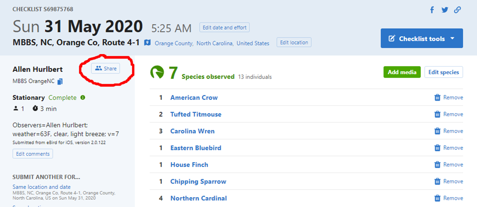
For Stop 1 only, enter information about observers and weather (and optionally, overall survey notes) for the survey as a whole. Also enter information about vehicles and habitat, as in the following example:
- “observers=Allen Hurlbert, Sarah Pollack; weather=55 F, clear; notes=big thunderstorm last night, everything wet; used Merlin Sound ID for confirmation; vehicles=3; habitat=B,H”
These comments must be formatted in this very specific way in order for us to easily extract this information later. Please make sure you use these conventions:
- Separate the different types of information (observers;
weather; vehicles; etc.) with a semi-colon,
and only use a semi-colon for this purpose.
- The key to allowable habitat codes can be found below. The convention is to specify habitat on the
left side of the road first, followed by a comma, and then habitat on
the right side of the road.
- Instructions for counting vehicles can be found here.
- Separate the different types of information (observers;
weather; vehicles; etc.) with a semi-colon,
and only use a semi-colon for this purpose.
For Stops 2-20, enter information about only vehicles and habitat (in particular, if habitat has never been entered before, or if it has changed since the previous year) in the checklist comments field. Two examples, including an acceptable shorthand:
- “vehicles=3; habitat=B,H”
- “v=3; h=B,H”
- “vehicles=3; habitat=B,H”
Some notes about using Merlin Sound ID, which some people find helpful as a means of alerting them to birds singing, or of confirming songs or calls they are on the fence on. If you use Merlin Sound ID to assist you during your point counts:
- Do not add birds identified by Merlin to your point count list
unless you can personally verify the presence of the bird by sight or
sound. Merlin is not perfect and occasionally has false positives.
- Add a note to the comments for Stop 1, e.g. “notes=used Merlin”. This is important because if the use of Merlin is increasing the average detectability of species in our survey records, we’d like to know when it was and was not used to better interpret apparent species trends.
- Do not add birds identified by Merlin to your point count list
unless you can personally verify the presence of the bird by sight or
sound. Merlin is not perfect and occasionally has false positives.
When submitting an eBird checklist from a particular stop FOR THE FIRST TIME, you must name the survey stop location in the specific way described below:
- Tap Choose a location at the top of the screen
after you have hit the Submit button in the mobile
app.
- Select the “New Location (auto selected)” that it suggests in orange font 0 ft away.
- Tap the green Create Location button.
- Your approximate address as determined by the GPS will be displayed. Click on the ‘X’ to the right of that address to clear it.
- Name the location as follows, MBBS, <County>, Route
<R>-<S>. Be sure to replace the text inside the
<>’s as in these examples (R stands for the route
number, S stands for the stop number):
- MBBS, Orange, Route 4-2
- MBBS, Durham, Route 13-20
- MBBS, Chatham, Route 1-1
- TIP: If you know how to copy and paste text on your phone, you can select the text for everything but the stop number e.g., “MBBS, Orange, Route 4-”, onto your phone’s clipboard. Then you should be able to paste it in the Location field and simply add the stop number, which may be faster than typing the whole thing.
- MBBS, Orange, Route 4-2
- Tap Choose a location at the top of the screen
after you have hit the Submit button in the mobile
app.
If you have previously submitted individual stop-based eBird checklists from your survey route, then you may be able to rename these existing locations according to our new convention in advance using the Manage My Locations feature of the eBird website.
- NOTE: If you previously specified “Orange Co” or
“Orange County” in the stop location names on eBird, that’s fine and you
may continue to use those names.
- Next year it will be even easier! After you have entered these location names once for your survey route, in the future, you will simply be able to select the stop location from the list of locations that automatically pops up in the mobile app.
- NOTE: If you previously specified “Orange Co” or
“Orange County” in the stop location names on eBird, that’s fine and you
may continue to use those names.
Connectivity issues. If you have no connectivity at a survey stop, it may not let you choose the location or submit the checklist. That’s ok!
- Once you’ve finished recording birds from the 3-minute survey, simply ‘X’ out of the checklist in the top right. The checklist will now be listed in the Not Submitted section of the app.
- When you get home (or elsewhere with a signal), you can then tap the
checklist which will open where you left off. Tap the green
Review button in the lower right.
- Tap Choose a location…. Your phone’s GPS should
have accurately recorded your location, and you should now be able to
select the named location, or if this is your first time at the stop,
follow the instructions above to name it.
- You should now be able to tap Submit.
After the survey
Review the Comments fields of your checklists, and edit or update them as necessary. This may be easier to do on a computer back at home than on your phone.
Make sure that the Comments for Stop 1 has observer and weather info!
Share ALL 20 checklists from your survey route with the appropriate MBBS account (
mbbsorangenc,mbbsdurhamnc, ormbbschathamn). This is an extremely important step, and without it, it is as if the surveys were never conducted as far as the project is concerned. We need the observations centralized in these accounts.
To share an eBird checklist, log in to the eBird website, go to Manage My Checklists, and click on the checklist you want to share. You will see a Share button next to your name as seen in the example below.
Once you click the Share button, you can enter the appropriate MBBS eBird account name (mbbsorangenc in the example below), and click the green Share Checklist at the bottom left.
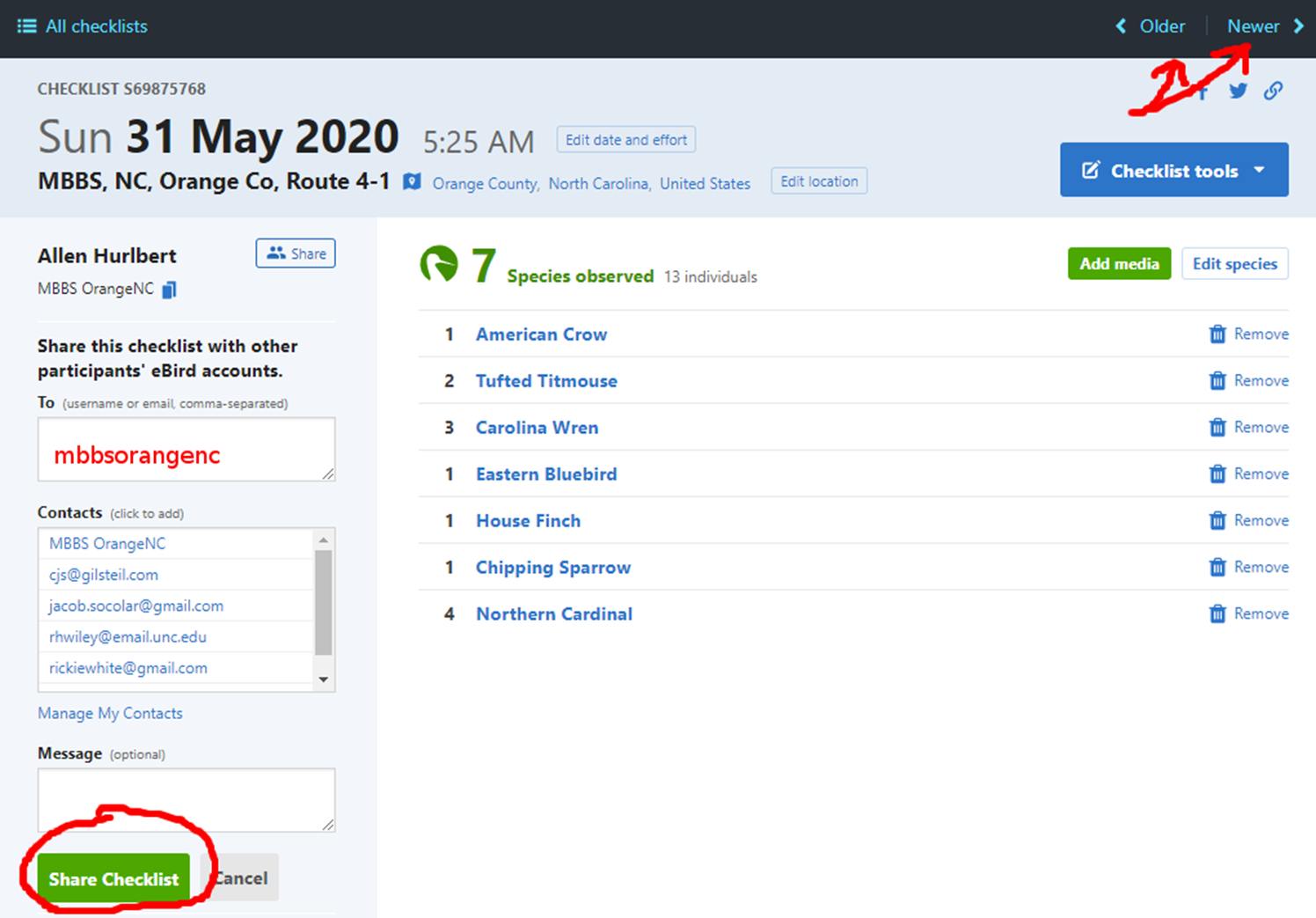
Unfortunately, there’s no easy way at the moment to share all 20 checklists in one go. But you can quickly navigate between your checklists using the Older or Newer buttons at the top right, re-paste the MBBS eBird username, and click Share Checklist, and it should take only a few seconds per checklist to get them all shared with the MBBS account.
Habitat
Codes for Seven Major Habitat Categories
- B – building(s) (except permanently abandoned ones) and areas heavily used by humans (lawns, athletic fields, golf courses, barnyards)
- H – forest (treetops touching each other) with hardwoods composing more than 90% of the canopy
- M – forest with pines and hardwoods mixed in the canopy (hardwoods 50-90% of the canopy)
- P – forest with more than half the canopy pines (hardwoods less than 50% of the canopy)
- S – second-growth (including areas with shrubs or scattered trees)
- 0 – open areas with low vegetation (recent clear-cuts, agricultural fields including fallow and hay fields) – but not lawns and athletic fields (these are coded B as explained above)
- W – water (lake, pond, river, stream) – often used as a secondary code after one of the above codes
Recording Habitat
- Each year take along your codes from previous years and use the same codes again – except…
- When you see that the habitat at a stop has changed (for instance, a clear-cut has become overgrown, a new clear-cut or development has replaced forest) – mark the new habitat code with an asterisk.
- Focus on the habitat directly to the left and right of the exact place where you stop (if the stop is at an edge between two kinds of habitat, make a decision about which side of the edge you are on, even if only by one foot!).
- Ignore any narrow strip of habitat parallel to the road (for instance, a line of trees or shrubs between the road and a field).
- Make a judgment about the predominant habitat within 50 meters (yards) of the road (half the length of a football field).
- If more than one code applies to one place, list the appropriate codes in order from the most to the least predominant (three codes maximum, please!).
- If there is a building (not permanently abandoned) within 50 meters (yards), record code B first, regardless of what surrounds the building.
Vehicle Count Procedure
The objective in counting vehicles at each stop is to produce information about the overall level of human activity along a route and any changes in this level from year to year.
- Count the number of vehicles during a three-minute period at each stop. Usually you can count vehicles during the same three minutes you count birds. Any contraption moving on the ground with a motor counts as a vehicle!
- If you extend the three minutes for counting birds to compensate for heavy traffic, do not make an extension for the traffic. Instead just count vehicles during the first three minutes – whether or not the traffic is heavy!
- If things are happening fast (lots of birds, lots of traffic), then the birds come first! Count the birds the best you can – and estimate (guess) the number of vehicles the best you can.
Routes
A temporary map of the stop locations for all routes can be found here.